
The Ultimate Guide to Drone Surveying in South Africa

🚁 What Is Drone Surveying?
Drone surveying uses unmanned aerial vehicles (UAVs) equipped with high-resolution cameras and positioning systems to collect geospatial data from above. This data is processed into detailed maps, models, and analytics for land measurement, infrastructure planning, and monitoring.
Unlike traditional methods, drone surveys are:
Faster
More affordable
Less invasive
Highly scalable
It’s an ideal solution for industries that rely on precise terrain data.
🛰️ What Does Drone Surveying Deliver?
With the use of photogrammetry, drones capture overlapping images to produce:
Orthomosaics: Accurate 2D stitched aerial maps
Point Clouds: Dense 3D datasets for modelling and volume calculations
Digital Elevation Models (DEMs): Elevation maps for terrain analysis
Contour Lines: For planning, grading, and hydrological studies
Volumetric Measurements: Track stockpiles and earthworks with precision
🧠 Benefits of Aerial Surveying
BenefitImpactSpeedComplete surveys in hours, not daysAccuracyAchieve 2–5 cm precision with RTK and GCP workflowsCost EfficiencyReduce manpower, time, and equipment overheadSafetyNo need for workers in hazardous or hard-to-reach areasScalabilitySurvey small plots or massive industrial zones

📍 Who Should Use Drone Surveying?
Drone surveying offers measurable benefits for:
🏗️ Construction Companies
Pre-site assessments
Earthworks progress tracking
Site layout verification
⛏️ Mining & Quarrying Operations
Stockpile volume tracking
Blast planning
Pit and slope analysis
🧱 Engineering & Infrastructure Firms
Road and bridge corridor mapping
Utility route planning
Cut-and-fill analysis
📐 Land Surveyors
Faster topographic surveys
Reliable 3D outputs
High-resolution data for CAD and GIS platforms
🧰 Why Photogrammetry Is a Game-Changer
Photogrammetry is the process of turning 2D images into 3D spatial data. It allows drones to map large areas with accuracy and consistency, enabling detailed measurements without physical contact.
When paired with tools like RTK GPS, ground control points, and precision cameras, photogrammetry becomes one of the most powerful tools in the modern surveyor’s kit.
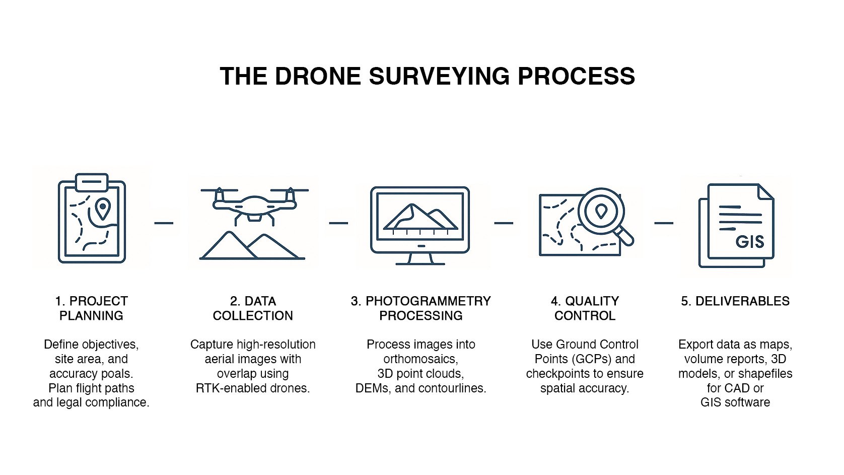
🔄 Typical Workflow
Project Planning – Define objectives and flight paths
Data Collection – Conduct flights with appropriate overlaps
Photogrammetry Processing – Generate maps, models, and metrics
Quality Checks – Ensure accuracy using ground control points
Deliverables – Export final outputs to CAD, GIS, or PDF formats
❓ FAQs About Drone Surveying
How accurate is drone surveying?
With the right equipment and control points, accuracy can be as tight as 2–5 cm.
Can drones survey small and large sites?
Yes. Whether it’s a single plot or a multi-hectare mine, drone surveying scales to your needs.
Is it legal in South Africa?
Absolutely. All drone surveying must be done by licensed operators under SACAA regulations.
How quickly can I get the results?
Most projects are processed and delivered within 2–4 working days.
Do you offer recurring site surveys?
Yes. We offer retainer packages and custom schedules for regular data collection.
🏁 Final Thoughts
Drone surveying is more than just a new technology—it’s a smarter way to gather data for critical projects. Whether you need detailed terrain models, volumetric calculations, or fast turnaround mapping, aerial surveying helps you work faster, safer, and with more confidence.
📞 Book a Drone Survey Today
At Aerial Drone Solutions, we deliver professional drone surveying services tailored to your needs. We are fully SACAA-licensed and serve clients across South Africa in construction, mining, engineering, and land development.
📧 Email: info@aerialdronesolutions.co.za
📞 Phone: +27 72 049 6035
🌐 Website: www.aerialdronesolutions.co.za
👉 Request a quote or book a free consultation today.